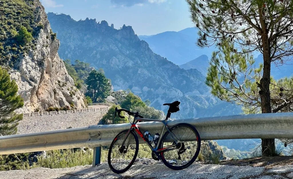
From gentle coastal spins to mountain passes through white villages - our favourite cycling routes starting from Frigiliana and Nerja on the Costa del Sol.
Frigiliana sits at roughly 300 metres above sea level, so a ride from our gate starts one of two ways and there is no third. Point the bike down the MA-5105 towards Nerja and the sea and you begin with a seven-kilometre descent, then pay for it with the climb home at the end of the day. Point it north into the Sierra de Almijara and you are climbing from the gate, with the descent saved as the reward on the way back. Neither is a warm-up, so spin the first kilometre easy whichever way you turn. What you get in return is some of the best road cycling in Andalucía: quiet tarmac through almond and olive groves, sweeping views of the Mediterranean, and white villages where you can refuel on coffee and tostada. The Axarquía region east of Málaga is increasingly popular with European cyclists, and for good reason - mild winters, empty roads, and climbs to suit every level. You do not have to bring a bike either: Cycle Nerja hire road, gravel, mountain and e-bikes and deliver them to the villa, so a cycling holiday here needs nothing more than your own shoes and helmet.
The eleven rides below run from the easiest to the hardest, ranked on distance plus climbing, so the first few are half-day spins and the last three are days you plan the rest of the holiday around. Each one carries the same four figures: how far it is, how much climbing is in it, roughly how long it takes to ride, and which way it starts from our door. Distances and high points are measured off the GPX line the map draws, so the figure and the picture can never disagree. Climbing is measured the same way wherever the file carries elevation; on the two that do not - Lentegí and the Ruta de la Cabra, both plotted on a road router rather than recorded on a bike - it is modelled from the terrain instead and given as a round number, so read those two as close rather than exact. Riding times are moving times for a moderately fit rider: reckon on 24 km/h where it is flat plus an hour for every 700 m of climbing, slower again on gravel. They do not include the coffee.
How to read these: The fourth figure is which way the ride starts from our gate, because at 300 m above the sea there is no third option: "Descent" means you drop to the coast first and climb home at the end, "Climb" means you go up into the sierra first and are rewarded on the way back. The same four figures appear on the walks in our hiking guide, so you can compare a ride and a walk on the same terms. Under the text of each ride, above its map, is the GPX file - the same line the map draws. Download it and put it on your own computer or head unit before you set off.
1. Torre del Mar and back along the coast
- Distance
- 52 km
- Climbing
- 394 m
- Riding time
- 2 hr 45
- Getting there
- Descent
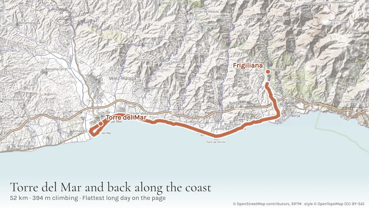
The flattest long ride on this page, and the one to do if you want distance in your legs without a mountain in the way. It drops to Nerja and runs west along the old N-340a through Torrox Costa, El Morche and Algarrobo Costa to Torre del Mar, then turns for home the same way. Fifty-two kilometres for under 400 m of climbing, and nearly all of that is the last seven kilometres back up to Frigiliana - the ride never gets above 237 m until it comes home. The coast road is quiet now the motorway has taken the through traffic, and there is a café every few kilometres if you want one. This is a traced line rather than a drawn one: it is a ride out of our own Strava, on 24 October 2025, so the distance and the climbing are what a bike actually did, not what a computer estimated.
Tip: Best ridden into a headwind on the way out. The prevailing breeze along this coast comes from the west in the afternoon, so going out west early means it pushes you home.
2. Frigiliana, Torrox and Nerja circular
- Distance
- 32 km
- Climbing
- 577 m
- Riding time
- 2 hr 10
- Getting there
- Climb
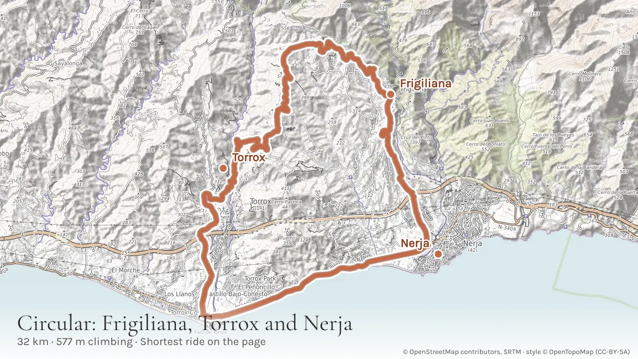
The shortest ride here and the best first morning of a holiday: a 32 km circuit linking three villages, with 577 m of climbing and a high point of 463 m. Unusually for a route from our gate it goes up before it goes down, climbing west out of Frigiliana on the road towards Torrox rather than dropping to the sea, which means the hard part is done inside the first hour. From Torrox pueblo the road falls to the coast, and you come back east along the old N-340a through Torrox Costa into Nerja before the familiar seven kilometres back up the MA-5105. Two hours and a bit, or three with a coffee on the plaza in Torrox, which is what the square is there for.
Tip: Do this one first. It is the only ride here that gets its climbing out of the way at the start, so it tells you honestly what your legs are like before you commit to a longer day.
3. Río de la Miel climb
- Distance
- 53 km
- Climbing
- 1,414 m
- Riding time
- 4 hr 15
- Getting there
- Descent
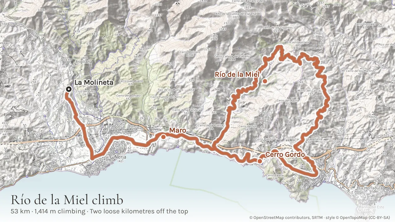
A local favourite, and one of two rides on this page drawn from something we actually recorded - our own GPS track, timestamps and all, rather than a line drawn on a computer. It is a loop in the strict sense: it starts and finishes at our own gate, 216 m up, and the line we hand you closes to within eight metres of where it opened. Fifty-three kilometres with 1,414 m of climbing. It drops through Nerja to the sea, runs east along the coast past Maro, crosses the A-7 at the twelfth kilometre and turns inland to climb the Río de la Miel valley, loops high above Almuñécar, then comes back along the old coast road and climbs home the way it left. The total sounds moderate and the ride is not, because almost half of the climbing sits in one place. From the crossing at 85 m the road goes up for very nearly eleven kilometres with nothing flat in it, to 753 m - an average of 6.2%, with the steepest kilometre, near the top, at 10.7% - so it is the better part of an hour and a half of climbing taken in ramps that follow one another rather than in short bursts you can ride over. The high point at 757 m is just over the provincial line into Granada, and the view is the reward. Then it turns for home: down to 528 m, round the back of Capellanía and out to the coast at the Marchante viaduct. There is one road tunnel on the way west, under Cerro Gordo, some 600 m of it - the receiver lost lock inside, which is how we know the ride went through it rather than over the top. Two fifths of the distance is ground you cover twice, because the coast road between the gate and the foot of the climb is the way out and the way back. The last thing the ride does is climb: from 37 m, three and a half kilometres at 5.5% up to the door, arriving with fourteen hundred metres in the legs. Take a gravel bike, or at least a road bike on the widest tyres it will swallow. The climb up is tarmac, and so is most of the way down, but the first two kilometres off the top - from the high point at 757 m to about 520 m - are loose track, which is the worst place on the ride to be on 25s. That one stretch is very nearly all of the unsealed riding on the route: about 5% of the distance, and the tarmac comes back for the rest of the descent.
Tip: This is a route the locals use for racing - do not underestimate it. The big climb does not start until the twelfth kilometre and the last three and a half are uphill as well, so do not spend everything in the valley.
4. Cómpeta and back, out through Torrox
- Distance
- 58 km
- Climbing
- 1,368 m
- Riding time
- 4 hr 25
- Getting there
- Climb
The most satisfying half day on this page, and one of our own rides rather than a plotted line, so the distance and the climbing are what a bike actually did. It goes up before it goes anywhere: west out of the gate on the Torrox road, over a 484 m shoulder inside the first seven kilometres, then down into the Torrox valley to 177 m, the lowest point of the day. What follows is the climb the ride exists for, the river road north through vines and almond terraces to Cómpeta, 620 m up and hung on the side of the sierra. Stop there for a well-earned lunch, because Cómpeta is exactly halfway and the second half is the first half backwards: a long descent off the village, one honest climb back out of the valley, and then the last few kilometres tip downhill to our gate.
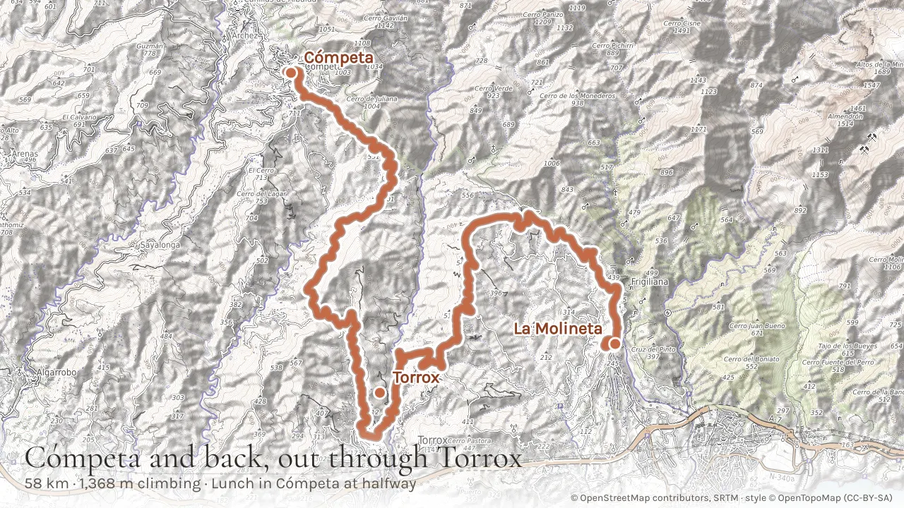
Lunch at the top: Cómpeta feeds people all afternoon around the church square, so there is no need to book or to hurry, and the village is high enough that the terraces stay bearable in summer. Fill both bottles before you roll out of it: there is nothing between Cómpeta and the valley floor, and the last climb of the day is still in front of you.
5. The N-340 coast road and the Cerro Gordo loop
- Distance
- 66 km
- Climbing
- 1,445 m
- Riding time
- 4 hr 50
- Getting there
- Descent
Sixty-six kilometres east along the coast and back, and the ride to do if you want a long day that never once goes into the mountains: the high point of the whole thing is 230 m. What it has instead of a climb is a great many of them. The old N-340 east of Nerja does not run level for more than a kilometre at a time - it climbs onto each headland and drops off the far side, over and over, through Maro and over the Cerro Gordo cliffs into La Herradura and on to Almuñécar. That rolling adds up to 1,445 m without a single sustained ascent, which is a different kind of tiring and catches people out. The cliffs of the Maro-Cerro Gordo natural park fall straight into the water beside you for most of it and it is the best coastal road in the province. Bike lights are essential: the route passes through road tunnels.
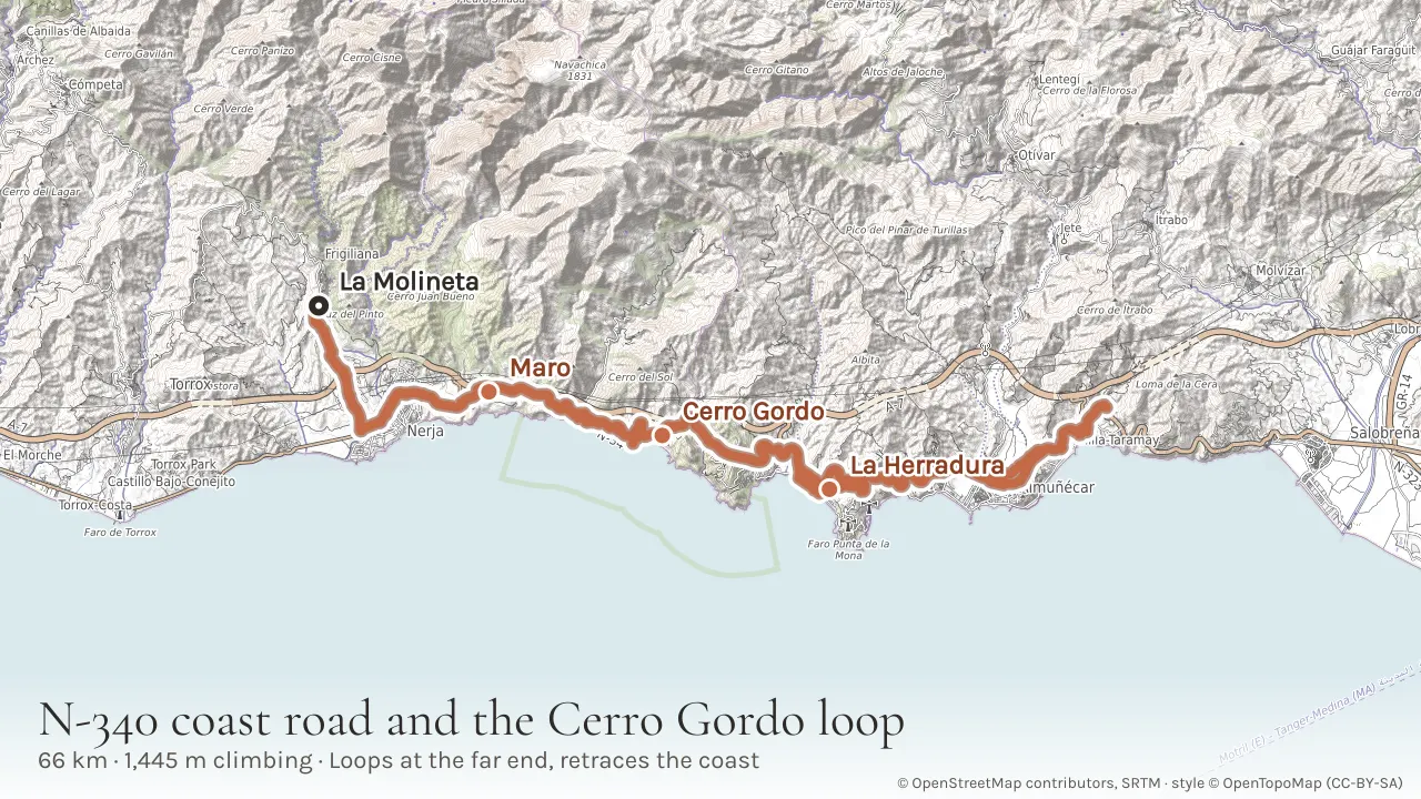
Tip: Turn round at Almuñécar seafront and eat before you start back. The rolling on this road is much harder in the second half than it feels in the first, and there is nothing between La Herradura and Maro if you run out of steam.
6. Gravel: the Sierra de Cómpeta circular
- Distance
- 42 km
- Climbing
- 1,143 m
- Riding time
- 3 hr 50
- Getting there
- Climb
The shortest of the hard rides and the one to take a gravel bike on. It leaves Frigiliana northwest on the mountain road, picks up the fire roads that run along the flank of the Sierra de Almijara, crosses to Cómpeta and comes back round - 42 km with 1,143 m of climbing and a high point of 936 m, roughly half of it on unsealed track. It sits here rather than further up the page because the numbers understate it: it is one of only two rides that climb from the gate, so there is nowhere to ease into it, and loose surface costs you time that tarmac does not. Because it is a circular you are never retracing your own tyre marks, and Cómpeta at the far end is the natural lunch stop. This is a plotted route rather than a recorded one, so treat the timings as an estimate and put the GPX on your own device before you set off.
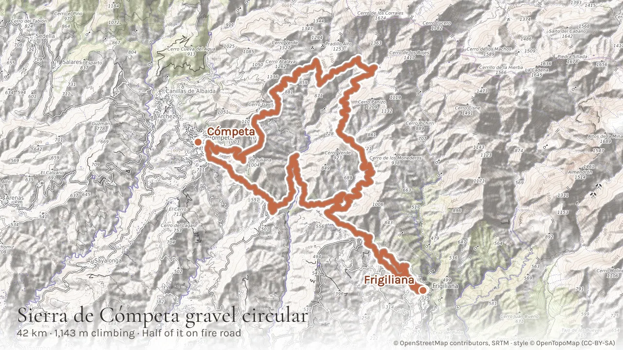
Tip: Fire roads, not singletrack, but they are remote: carry a spare tube, plenty of water, and tell someone your route. Mobile signal is patchy above the tree line. Avoid it in the days after heavy rain, when the surface washes into loose gravel.
7. The Axarquía Grand Loop: Nerja, Algarrobo, Cómpeta and Frigiliana
- Distance
- 68 km
- Climbing
- 2,677 m
- Riding time
- 6 hr 40
- Getting there
- Descent
The classic Axarquía day, and a full day rather than a morning: sixty-eight kilometres with 2,677 m of climbing, passing Algarrobo, Sayalonga and Cómpeta before the long way home over the hills to Frigiliana. The first half rolls along the old N-340 coast road, blissfully quiet since the motorway opened, before turning inland at Algarrobo. From there the road climbs for fourteen kilometres to the day's high point of 667 m just short of Cómpeta, relentless but beautiful through vineyards and pine forest, and Cómpeta itself is the lunch stop; try the local muscatel wine at one of the bars on the plaza. The second half is what makes the climbing figure what it is: the road falls to Torrox, climbs again to nearly 500 m on the mountain road back east, and only then comes down to Frigiliana. Ridden that way round, the hardest of it is behind you by early afternoon.
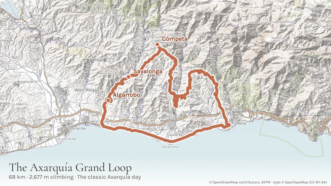
Tip: Carry plenty of water - there are few fountains between Sayalonga and Cómpeta. A bike with compact gearing (34/32 or lower) will make the Cómpeta climb much more enjoyable.
8. Canillas de Aceituno and the white villages
- Distance
- 94 km
- Climbing
- 1,834 m
- Riding time
- 6 hr 30
- Getting there
- Descent
The best full day on this page if you only get one, and the ride that shows you the Axarquía properly rather than in glimpses. Ninety-four kilometres with 1,834 m of climbing, out west along the coast and then a long swing north through the villages under the Sierra de Tejeda: Canillas de Aceituno, Sedella, Salares, Corumbela, and back over to Frigiliana. The high point is 692 m, so there is no single mountain in it, but the road between the villages barely stops going up or down for fifty kilometres and the middle third is the hardest thing here short of a genuine mountain pass. Canillas de Aceituno at roughly halfway is the place to stop, and the suspension bridge walk in our hiking guide starts from the same village if you want to come back another day on foot.
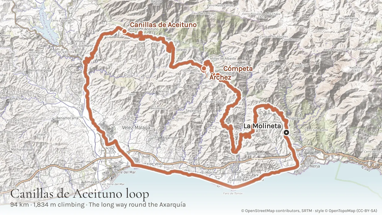
Tip: Fill every bottle in Canillas de Aceituno. Sedella, Salares and Corumbela are tiny and you cannot count on a bar being open in any of them outside the season.
9. La Herradura, Almuñécar and the climb to Lentegí
- Distance
- 95 km
- Climbing
- about 2,700 m
- Riding time
- 7 hr 50
- Getting there
- Descent
Heading east into Granada province, this is 95 km with more climbing per kilometre than anything else on this page bar the Ruta de la Cabra. Be clear about the shape of it before you go: it is an out and back, not a loop. The coast road east through Maro and over the Cerro Gordo headland is the same rolling, scenic run as ride five, then the route turns inland at Otívar and climbs steeply to Lentegí, a mountain village with sweeping views - and then you turn round and ride the same road home. There is no quiet back way down from Lentegí, which is why every version of this ride retraces itself. The compensation is that you descend what you have just climbed, with the sea in front of you the whole way. You will need bike lights, because the route passes through two road tunnels. Like the Ruta de la Cabra, this is a plotted line with no recorded elevation, so the climbing is modelled from the terrain: about 2,700 m.
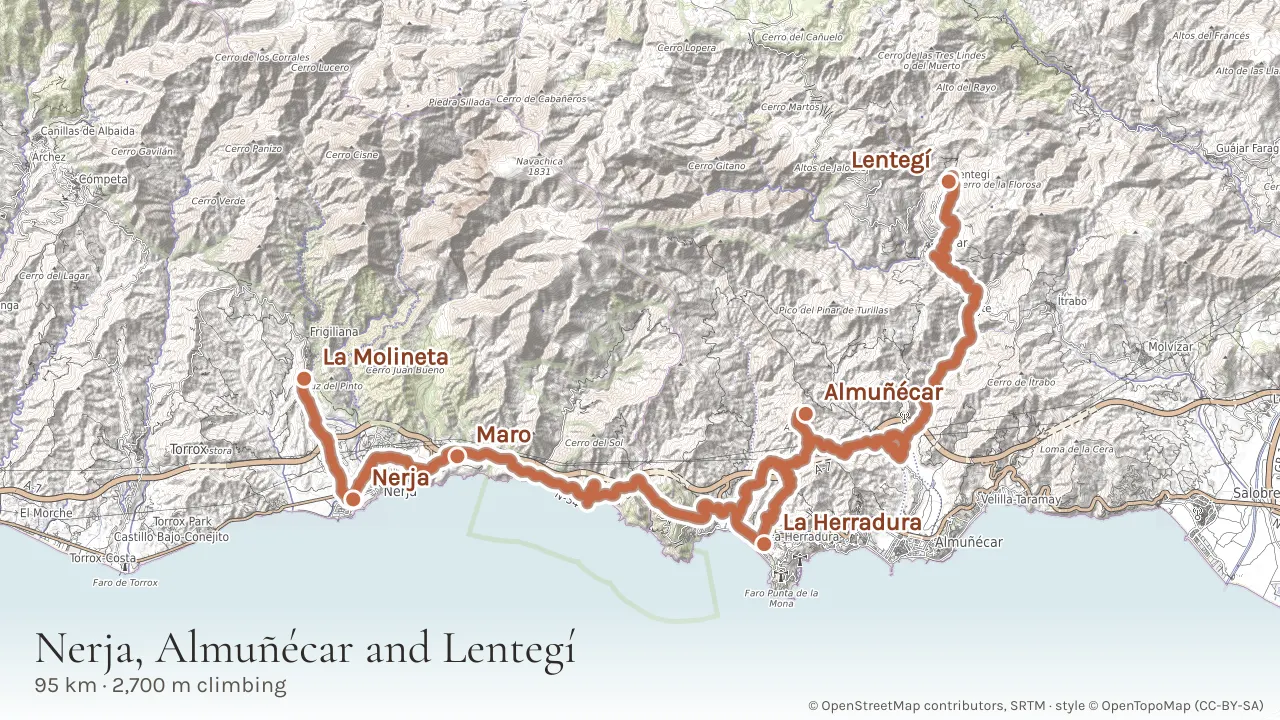
Tip: Stop at the Maro mirador in the first half hour for one of the best coastal panoramas on the Costa del Sol - on a clear day you can see the mountains of North Africa. Almuñécar is a good coffee and refuelling stop roughly a third of the way round. The climb to Lentegí is the hardest section - save your legs for it.
10. Puerto del Sol, Alfarnate and the Zafarraya pass
- Distance
- 139 km
- Climbing
- 1,756 m
- Riding time
- 8 hr 20
- Getting there
- Descent
A hundred and thirty-nine kilometres and the longest single day here: the full mountain circuit inland, with a coastal commute at each end. The first stretch runs west along the coast from our gate and the last stretch comes back along the same road; in between sits a long loop that turns inland through Vélez-Málaga and La Viñuela, climbs to the Puerto del Sol at 1,076 m - a tough 6.5 km ascent averaging around 6.5% with steep hairpin sections - then drops in a swooping descent to Alfarnate and comes back through the Zafarraya pass. The climbing total is lower than the Lentegí ride above it, which is exactly what makes it deceptive: the distance is where the day goes. Knowing that the two coastal legs repeat is worth something at hour seven, because the last stretch holds no surprises.
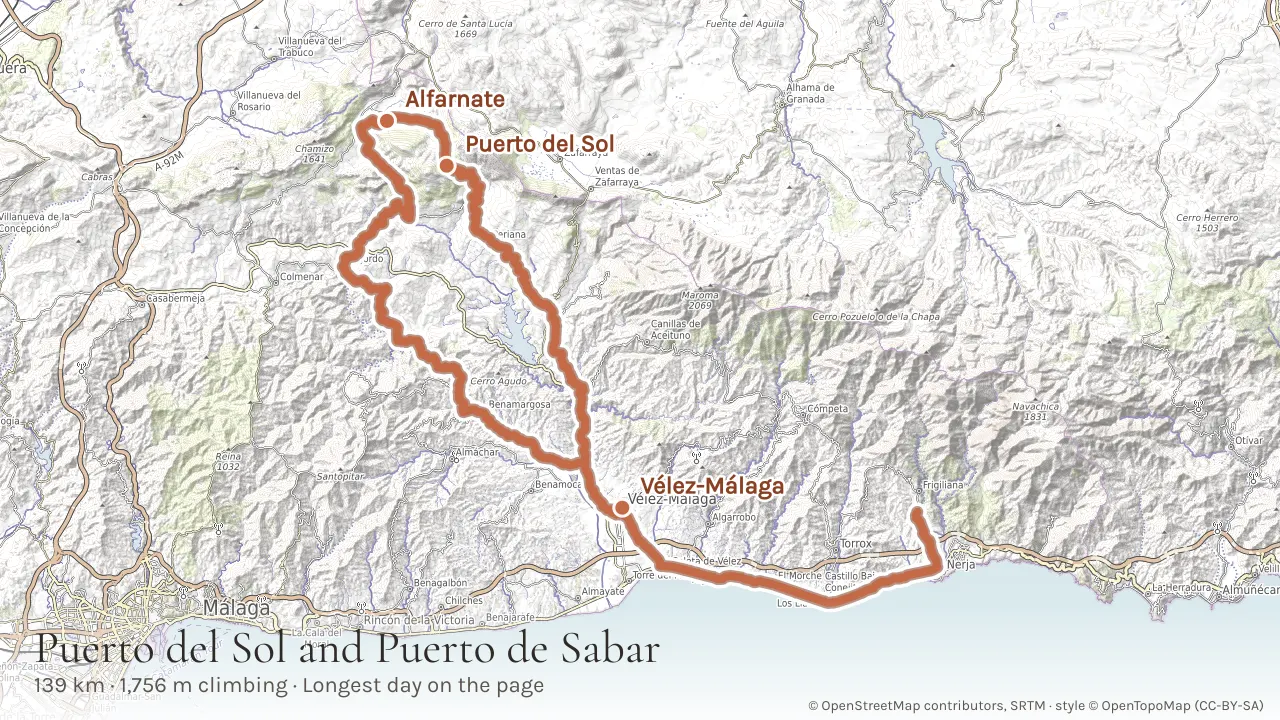
Tip: This is a serious ride - proper nutrition, hydration and fitness are essential. The views from the Puerto del Sol are worth every pedal stroke. Check the weather at altitude before setting out: the Zafarraya pass is a thousand metres up and can be ten degrees colder than the beach you started from.
11. Ruta de la Cabra - La Molineta to Granada and back
- Distance
- 214 km
- Climbing
- about 4,900 m
- Riding time
- 16 hr over two days
- Getting there
- Descent
The big one, and the only ride on this page that you cannot do in a day. Two hundred and fourteen kilometres from our gate to Granada and back by the Ruta de la Cabra, the Goat Route, with something like 4,900 m of climbing in it. This is a round trip, not a one-way run: you ride out east along the coast through Maro and Almuñécar, turn inland at Otívar and climb the Goat Route through the Sierra de los Guájares to a high point of about 1,360 m before dropping into the vega of Granada - and then, on the second day, you ride the whole thing back. It necessitates a night spent in Granada. There is no sensible way to compress it, and nobody should try: the return leg re-climbs the Goat Route from the Granada side, which is the harder direction. Book a bed before you leave. Bike lights are essential, because the route passes through tunnels, and the climbing figure is modelled from the terrain rather than recorded, so read it as close rather than exact.
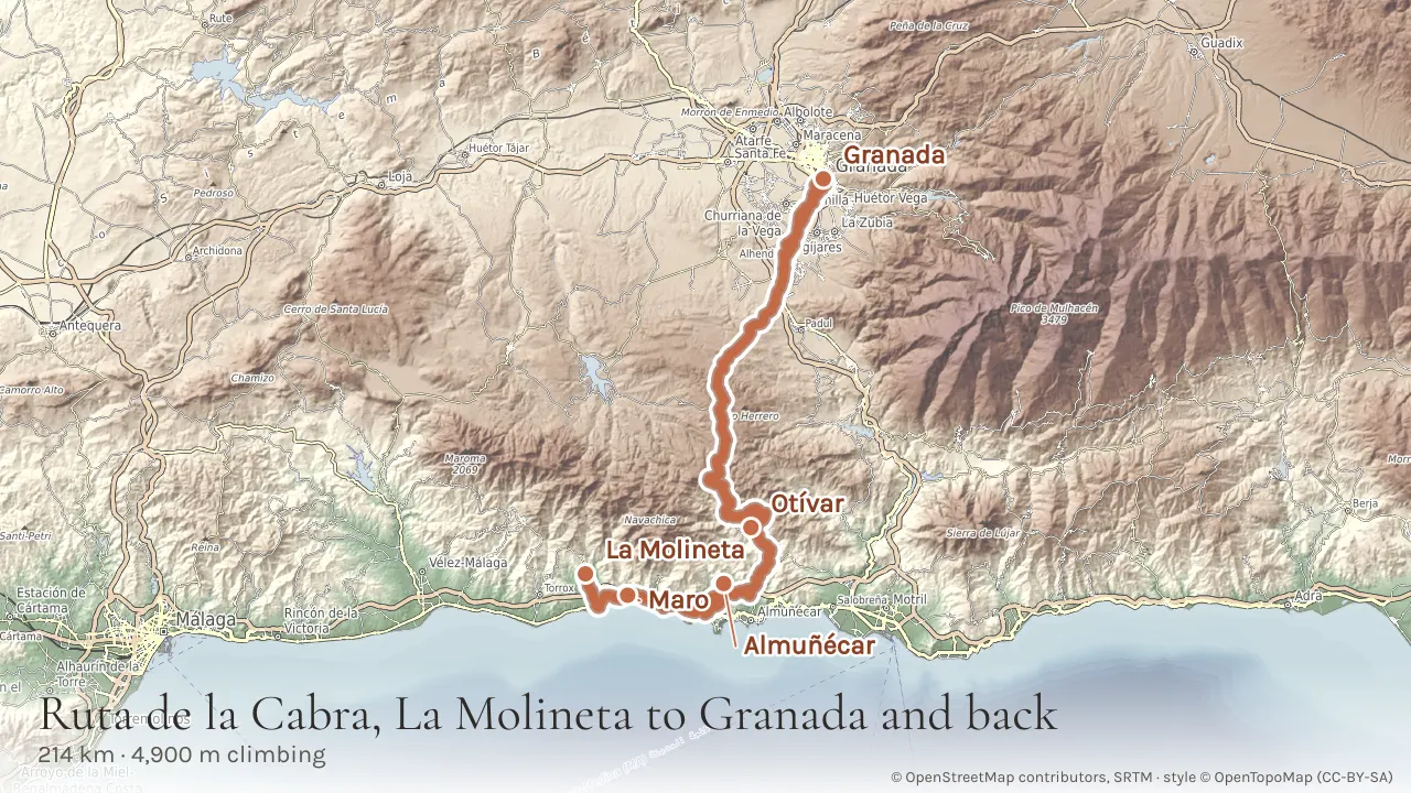
Tip: Lock the bike at the hotel and spend the evening at the Alhambra - book that ahead too, it sells out weeks in advance. Start both days at first light: the Goat Route has no shade and no water, and the second morning is the harder of the two.
Hiring a bike
You do not need to bring your own bike, and most of our guests do not. Cycle Nerja hire quality road bikes (Giant, Pinarello), gravel bikes, mountain bikes and e-bikes, and they deliver the bike to the villa and collect it at the end of your stay, so there is no wrestling a bike box through the airport or a hire car. Their staff are local riders, so the route advice that comes with the rental is worth as much as the bike: show them the ride you are thinking of and they will tell you honestly which climbs suit your legs. Book ahead in spring and autumn, when the Axarquía fills with cycling groups. Their bike rental page is below.
Practical tips
The best months for cycling are March to May and September to November - warm but not oppressively hot. July and August rides should start at dawn. Every ride on this page has its GPX file under the text, so there is nothing to hunt for: download it, load it onto your head unit or phone, and go. Strava, Komoot and Wikiloc all have extensive route libraries for the area if you want more. The roads around Frigiliana are generally in good condition, though watch for loose gravel on the tighter mountain bends.
Planning a trip to Frigiliana? Our villas are just minutes from the village - book direct for the best price.